


Well, so we’re building a new stadium for the Titans and we’re going to develop the East Bank of the Cumberland to do it. Many thoughtful people with good reasons spoke against this proposal, but the Metro Council metaphorically flipped them the bird and gave rich people our money. Which, I guess, is how they’re rich. If the city put in a third of the money for every harebrained idea I had and the state threw in a quarter of the funding, I’d have cool stuff and be rich too. I’m just sorry for all the people who took the time to speak and found the system rigged against them.
But I’m not here to bemoan the lack of a representative democracy in this city and state (at least not today). Nor do I care to wonder at the fact that we’re sinking all this money into a dying sport centered on watching men give each other brain damage so severe that it can lead them to kill themselves by shooting themselves in the chest so that doctors can have their brains to study to try to understand what went wrong.
I’m here today to put my marker down. I don’t really understand the intricacies of gambling, so I’m not sure if this is the right metaphor, but I believe I will have occasion to scream “I told you so” at this city, and I want to use this space to tell you the thing I’m going to say "I told you so" about in the future.
After we just spent the past 13 years buying people out of flood zones here in Davidson County, we are now committing the city to putting brand-new neighborhoods in a flood zone. And those neighborhoods will flood. It is as predictable as saying that a tornado is going to hit the city. We don’t know when, but we know tornadoes hit here, and it sucks. We know the Cumberland floods, and it sucks.

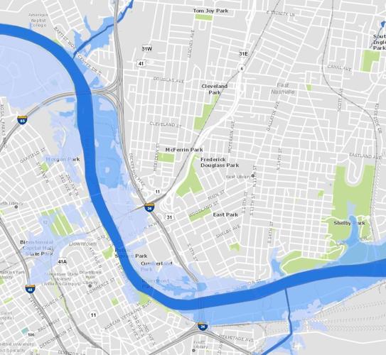
FEMA's Cumberland River floodplain map
You can check out the FEMA map and see just how much of our East Bank development sits in the floodway. The screenshot embedded here is a little less detailed, but you get the idea.
The East Bank plan offers some basic suggestions for how we’ll be dealing with flooding, But on page 86, there’s this telling sentence: “Short- and long-term riparian edge strategies should be further evaluated in concert with Metro Water Services and the U.S. Army Corps of Engineers.” Translating this into plain English, they still need to check with Metro Water and the Corps before they know if what they’re proposing works.
Man, I sure wish we hadn’t committed a bunch of money to do a thing we don’t even know if we can do. And I hope we all understand that we’re going to be on the hook for cleaning up the inevitable flood mess down there when it happens.
Ah, but what if we give up our dream of actually seeing the river and instead put up a flood wall? I spent some time on Saturday modeling out what might happen.

OK, here’s Nashville. The plastic-wrapped mac-and-cheese box is the rocky bluff downtown sits on. To the right is the soft, absorbent paper towel representing the East Bank. The Metro Center Levee is a poorly incorporated dough of flour and water. The Bordeaux bluff is represented by the side of the pizza box.

Here we have a mild flooding event. Note that the East Bank’s ability to absorb floodwater is keeping the water running by the levee fairly slow.

Even as water pressure increases, the East Bank is still helping reduce strain on the Metro Center Levee.

But if you put up a flood wall to protect the East Bank, the water rushes through the downtown area and hits the Metro Center Levee at greater force and with more water volume. You can see in this picture that the levee was starting to lose integrity.
But that couldn’t happen with the real levee, right? It’s not made of bread flour. I mean, certainly not. But what is it made of? Who knows? We just let the Mat-Nel Company build that levee in the early 1970s. Heck, we even traded them more space for their homemade levee in exchange for a garbage dump, which we capped off using the dirt dug up from the construction of Clarksville Pike in 1974 — then we expanded Ted Rhodes Golf Course another nine holes on top of said garbage dump.
Back in 2012, a local blogger tried to figure out how the levee was constructed. He wrote:
I don’t have any good idea of how the levee construction was done in this case, but a levee is usually constructed with an impermeable clay core surrounded by well compacted soil and built well above the expected flood elevation. It’s a very expensive undertaking, and from the reports I’ve seen the Metrocenter levee wasn’t constructed to any that exacting standard. It stood for nearly 30 years on its own so it obviously worked well enough to keep out the intermittent small floods on the Cumberland, but by the 1990’s the Metrocenter levee was starting to look shaky, and there was a lot of concern about it holding up through a major flood.
This timeline makes the situation a little less alarming than it actually seems to be. On June 16, 1985, The Tennessean reported that District 20 was asking for $500,000 for the stabilization of the Metro Center Levee. Then on Sept. 12, 1997, The Tennessean reported that, again, we were budgeting for Metro Center Levee stabilization. Then in the mid-2010s, we “modernized” the levee. Since then, we seem to have been OK, but we’re still dealing with a homemade levee that we had to stabilize every 10 to 15 years since it magically appeared on the riverbank.
Mystery Metro Center Levee? Brand-new East Bank development? This is a recipe for disaster. I don’t know which form the disaster will take — flooding on the East Bank or flooding in Metro Center. But it’s going to happen, and when it does, I’m going to point back to this post and say, “Nashville, I told you so.” This forthcoming tragedy is utterly predicable, so I’m predicting it.


