

To make a long story short, I thought I should map all these little Black villages I’m finding in Davidson County. That led to me trying to decide if Bryanttown was a real place, which led me to researching Bryanttown and then trying to go see it.
Was Bryanttown a real place? The short answer is yes. Sherrod Bryant, a free person of color and probably the richest Black man in Davidson County during his lifetime, had a large family. The kids he had with his first wife inherited a bunch of property that became known as Bryant’s Grove, which was in Rutherford County and is now mostly under Percy Priest Lake. The little that remains is in Davidson County down along Couchville Pike. His kids with his second wife got the land that would come to be called “Bryanttown” out on the eastern edge of the airport.

A trip to the final resting place of wealthy freedman and Davidson County landowner Sherod Bryant
In my research, I learned that Bryanttown had not only a cemetery (which I know we’ve talked about), but also a school and a church. After the first school burned down, they got a Rosenwald school, at which point the county shut the Donelson school down and sent all the Black children in Donelson down to Bryanttown. Students in Bryanttown gave recitations to social groups. Men got in scuffles at town picnics and had to hide in Bryant’s Grove for a while. And — AND — the four Davis brothers got kicked out of Bryanttown for being such menaces, and they robbed a guy in Goodlettsville and got caught in Springfield. They were on their way to Kentucky when they robbed the guy in Goodlettsville, and I’m not saying we should return to all our past ways, but before we give CoreCivic any more money, have we considered just exiling people to Kentucky?
I tried to learn all I could about the Davis brothers, but this was quite a challenge. That's because apparently all the Davis brothers in Davidson county in the early 1900s were either criminals or in a brass band. Or maybe both. I didn’t look that closely into the band. These Black Davis brothers, before being run out of Bryanttown, were beating up civil engineers. Some white Davis brothers in Hermitage faked a bank robbery — and I have questions. Is it a crime to fake a bank robbery? What makes it fake? Because it seems like the line between a fake bank robbery and a failed bank robbery is probably really thin. Some other white Davis brothers killed their mom. And some other Davis brothers had a minstrel show. Maybe that’s where the band originated? I don’t know. But if your last name is Davis and you seem old-timey and you don’t have a Sousaphone wrapped around you, I’m going to keep my distance.

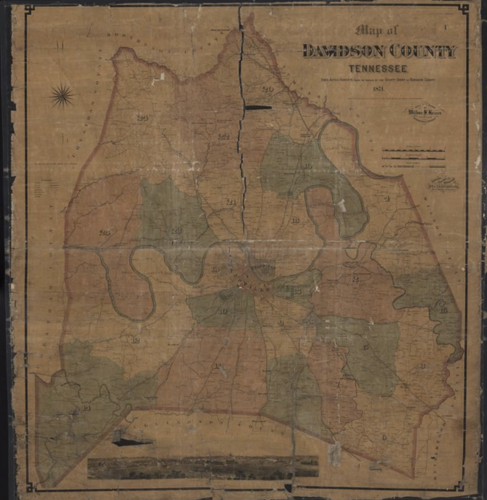
Wilbur Foster's 1871 color map of Davidson County Tennessee
OK, but where was Bryanttown? Once again, the Tennessee State Library and Archives comes to our aid. (TSLA motto: We have a map for that.) Check out the Wilbur Foster map of Davidson County from 1871, which shows landowners. (The map is also embedded here on the right, but the linked version is much higher resolution.) Let’s get situated. You’re looking for District 2 and, specifically, the “2” on the map. Below it you see “Allen,” and farther south Judge Frazier, and then, there on the other side of what we know as Elm Hill Pike, what they knew as Chicken Pike (Chicken Pike! Why did we give that up?!), you see on either side of McCrory Creek: S. Bryant, L. Bryant, Widow Dungy and J. Bryant.
L. Bryant is Laurenzella Scott Bryant, who was called Larzell or Scott. J. Bryant is his brother John. The Widow Dungy is their sister Catherine. At first I thought S. Bryant had to be Silas Bryant, but he has the wrong mom to be in the Bryanttown bunch. But if Catherine had land, then so could another sister. Their sister Sarah would have still been an S. Bryant at the time the map was made. She married later. (We’re not getting into who all the Bryants married, but there weren’t that many people out there for them to legally marry before the Civil War, and after the Civil War, many of them married Joseph Darr — the same Joseph Darr, just at different times — so it’s convoluted and confusing.)

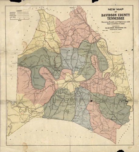
Colorful map of Davidson County published in 1926
So we have a bunch of Sherrod’s children along McCrory Creek with a road to the west. Now skip ahead to this awesome map from 1926. Use the creek and Elm Hill Road to situate yourself. There are five north-south roads running through the area. Hamilton Creek Road is under the lake, but Bell Road does what it used to do. The north-south Elm Hill Road doesn’t exist anymore, but the current north-south Pleasant Hill Road uses some of the old Elm Hill Road. There’s Combs Road (which seems to now be the current north-south Couchville Pike), Polk Avenue (which is roughly Donelson Pike now), and Fanning College Road (which is replaced by Briley now).
The Bryant properties that were along Polk are under airport runways now, but it looks on Google maps like the north-south Couchville Pike is still open. So off I went. It’s not open. The airport has closed the road and surrounded all of the old Bryanttown area with a fence. Can the airport do that? Just commandeer a city road and decide no one can drive on it? Also, is that fence adhering to codes? A barbed-wire fence has to be seven feet tall before the barbed wire starts, and the barbed wire has to be tilted into the fenced property. It’s clear as day in the Metro Codes — title 16, chapter 4, article 3, section 200, part b: “In all zoning districts, no fence otherwise permitted under this code shall be erected with barbs or sharp projections on top of such fence, unless it is five feet or more from a property line or more than seven feet above grade and projecting inward.”
I was pissed. Can the airport just cut off access to a road that is still on Google Maps and still in the parcel viewer? And with non-code-compliant fencing? I’d complain, but to which airport authority? There’s like 75 of them now, I think, all competing for the right to tell me I can’t go see history stuff that interests me. At least there’s still the Bryanttown Cemetery, unmolested by shitty fences and land grabs.
I said, AT LEAST THERE’S STILL THE BRYANTTOWN CEMETERY, UNMOLESTED BY SHITTY FENCES AND LAND GRABS! Donelson, damn it, I don’t ask you for much. Just value your cool shit.

But no, I go over to the Bryanttown Cemetery and there’s a goddamn fence right along the lane that's probably the top of the old Combs road that runs through the cemetery. A screenshot from Google Street View (embedded above) shows that, until late last year, the cemetery had a great deal of room to the left of its gate. That is no longer the case. The neighboring business has put up a fence with the barbed wire pointing the wrong way in the cemetery.
This is exactly how Benevolent Society #2’s cemetery got stolen — landowners on either side of it just slowly encroaching and encroaching and encroaching. But at least that cemetery wasn’t still being used. Can you imagine being the family who shows up for the next interment out there only to find the cemetery has shrunk? Here’s how you know curses aren’t real. People just steal parts of 200-year-old cemeteries but they aren’t infested with hundreds of warts on their faces or haunted by any of the various criminal Davis brothers.
I didn’t know what to do, so I emailed Metro Historical and the state’s cemetery guy. They went out and looked at the cemetery, and they also thought the fence situation was, shall we say, strange. They have a ton of stuff they could do for the cemetery to help them try to reclaim the land, but they need someone who represents the cemetery to ask them to do it.

Exploring the history of one of Nashville’s long-overlooked Black burial spaces
I tracked down the Bryant in charge of the cemetery, but he never answered the message I left him. Which is fair. I’m sure he didn’t know who I was, probably didn’t know what the Nashville Scene is, and has better things to do with his time than talk to me. But I hope he or someone else associated with the cemetery will at least reach out to Metro Historical.
So much of Bryanttown is lost. This spot, at least, should be protected. And if any of Sherrod Bryant’s descendants want to run around near the airport putting up fences on other people’s property, count me in. Good fences make good neighbors, and folks are setting the precedent that we can just put fences wherever we want. So why not? Turnabout is fair play, and that was all Bryanttown to start with.