

On Dec. 5, Meritage Homes of Tennessee petitioned the Chancery Court for permission to remove an abandoned cemetery on land they’re developing in Hermitage, just off Tulip Grove Road. On Dec. 9, Sara Harvey and I went out to the site to try to get a look at this cemetery.
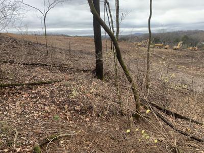
We didn’t find it. What we found at the GPS coordinates where the cemetery is supposed to be is a lot of mud and some huge holes. Access to the site, which is supposed to be possible on a public road, was barred by a giant piece of construction equipment placed across the road. We decided to hike in from the north, and Harvey walked up and down the hillside where the cemetery is supposed to be. (For the sake of transparency, I confess I stood in a flat spot in the middle of the hill like the coward I am yelling at Harvey to please not fall, because she had both our phones.) She found nothing that resembled graves.
But, y’all, what is there even to say? A cemetery on the side of a steep hill? According to the developers, containing anywhere from 25 to 50 people, mostly marked with fieldstones? How many of these sites have I hauled you along on, dear readers? Benevolent Society #2. The Edmondson Cemetery in Lake Providence. The cemetery on the hillside Janet Timmons had to drag me up. If there’s a secluded hillside near an old Black community in Middle Tennessee with graves on it, those graves belong to that community. That’s the pattern we see over and over.
This is or was (I’m keeping this ambiguous in the hopes that two people very experienced with looking for and at rural cemeteries are wrong about the cemetery already being gone) a Black cemetery.
Let me quote from the petition: “The persons believed to be buried in the Cemetery and their dates of death and birth are unknown. The graves are largely marked by fieldstones. … The Cemetery is likely from the 19th century, and there may be between twenty-five to fifty individuals buried at the Cemetery. … In this case, due to the lack of information pertaining to the Cemetery, the potential heirs of the persons buried at the Cemetery cannot be ascertained.”
The developer has another subdivision down closer to Central Pike on Tulip Grove. Its main thoroughfare is Evans Hill Way. There’s an Evans Hill Court in there, too. Do you know what Evans Hill is/was? Like Lake Providence or Briarville or Needmore or Scotts Hollow or Hardscuffle, it was a rural Black community that sprang up after emancipation. So, these developers are cued in enough to the history of the area to know about Evans Hill, but not enough to guess who that cemetery in their development to the north might be full of? I’m not buying it.
Here is how we lose these rural Black cemeteries: 1. We ignore the fact that it was illegal for enslaved people to read and write, so they weren’t going to mark their graves with people’s names. Instead, we use a lack of name-marked graves as evidence the site isn’t important. 2. We don’t recognize that enslaved and newly emancipated people had different ways of marking their graves than what was the fashion of rich white people, and instead, we call the plants and trees that were used to decorate graves “overgrowth.” 3. We make it impossible for people to access the cemetery, and we call it abandoned. 4. We develop over it.
It just feels like cheating, to stack the deck that much against rural Black cemeteries and then throw up your hands and say “We just can’t know who was in here.”
So, what can we know? Thanks to this map at the TSLA, we know what white people were living in District 4 right after the Civil War and thus were likely to be the same people, or at least the same families as the white people before the Civil War. And we know, based on the last names of the earliest recorded Black burials in the district that, when Black people left the plantations where they were enslaved, they went east, into the hills. We also know that people from neighboring plantations intermarried.
In 1870, according to the census, there were 345 dwellings in District 4. There were 787 white people and 912 Black people — 1,699 people in total. In the whole district. If we assume that the people buried on the hill had been enslaved or were the descendants of people enslaved nearby, we need to see who nearby had a large enough enslaved population to spawn a community with a good-sized cemetery.
In 1850, the largest populations of enslaved people were on Donelson farms (including The Hermitage) — 370 people. They might have been too far away for many of them to have ended up near this hillside, but the Shutes had 64 enslaved people. The Dodsons had 40. The Gleaveses had 33. By 1860, the nearby Bakers had 12 people enslaved.
And we know who was nearby to marry into the families that might have been there. In the nearby Scotts Hollow cemetery, there are Bradleys and Cockrills (and Cockrells), Dodsons and Kittrells, Etherlys, Jacksons, and Shutes. At the other end of Tulip Grove, in the Evans Hill Cemetery, you find Brookses, Etherlys, Evanses, Hayeses, Jacksons and Robertsons. Even over in Greenlawn Cemetery, there are Jacksons and Bradleys. You might just start asking questions of any old Black person along Tulip Grove with these last names.
People haven’t left. And even if they have left, many of them come back on Sundays to go to the churches their ancestors built by hand. There were only 50 slave-owning families in District 4. Only about a quarter of them lived near this cemetery. We may not know the names of the individuals in this cemetery, but we know who they were — people, and their descendants, who had their lives stolen from them by slavery, and now they’ve got their deaths stolen by development.
What a sad and fucked-up way for Nashville to deal with its history.