

Gaze across the water and onto the glory of Shackle Island!
Among the more mysterious places in Middle Tennessee is Shackle Island. Other than New Shackle Island Road, Old Shackle Island Road, and the Shackle Island Volunteer Fire Department on Long Hollow Pike, across from the ancient Beech Cumberland Presbyterian Church ("The oldest Cumberland Presbyterian Church in the World!"), there's not much clue left in today's landscape as to where Shackle Island was, what it was, why it was called that, and whether you could go see it now.
And yet, if you're any kind of history buff, this mysterious Shackle Island keeps popping up. The oldest history books tell us the long hunters often hunted near Shackle Island. Just this week, the Tennessee State Library and Archives posted a neat letter from Dr. Joshua Franklin to Daniel Montgomery in which the Doctor was ordering a dollar's worth of whiskey from Montgomery's distillery so he could make medicine. According to the biographical note in the TSLA's finding aid, Daniel Montgomery was born in 1789 in Sumner County and he "engaged in extensive farming operations and operated a grist mill, a sawmill, and a whiskey distillery at Shackle Island in Sumner County." In 1855, he "died at Shackle Island, buried in Beech Cemetery."

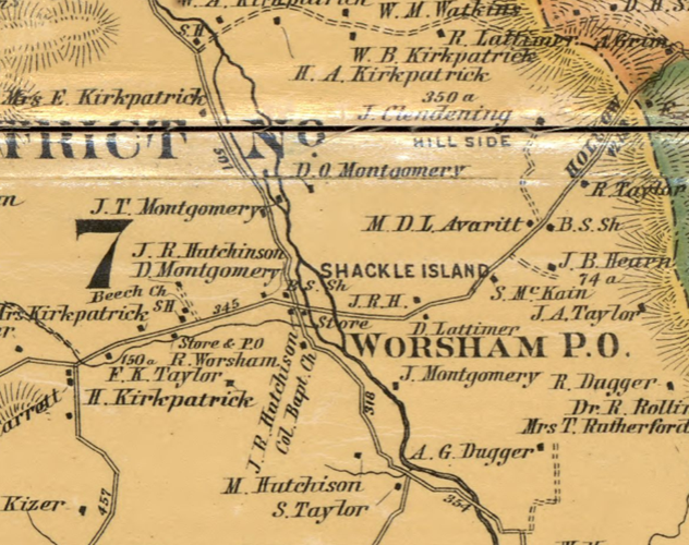
From this we learn a lot: by the mid-1800s, Shackle Island was a community and it was probably very near the Beech Cumberland Presbyterian Church, since people did not haul their dead that far to bury them (with the exception of Adelicia Hayes Franklin soon-to-be-Acklen, who put Isaac Franklin in a whiskey barrel in Louisiana and shipped him north preserved in the spirits to be buried in Sumner County.). I checked out this awesome 1878 map of
Sumner County at the Library of Congressand, lo and behold, there's the community of Shackle Island and there are Montgomerys living right along the creek, neighbors to the Beech church (I suspect that B.S. right at the corner of Long Hollow Pike and what is now New Shackle Island Road stands for Beech School, which leads me to suspect that the acre of land the TSLA says Daniel Montgomery gave for a school in the community was, in fact, right there, where there is still to this day a Beech School.)
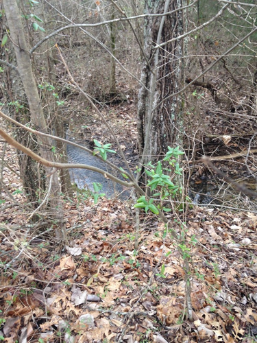
But the most important thing that map shows us is that there was an actual island and it was right there, on the other side of the road from the Beech School. I've driven out that way a lot and I don't ever recall seeing an island or even crossing two streams, and, obviously, an island would have to have water on all sides. I looked on Google maps and there's no trace of the eastern branch of the creek that would have been the boundary of that side of the island. But I went out there on Saturday and thanks to having the 1878 map, I knew where to look. The western branch of the creek is very easy to locate. It runs right next to New Shackle Island Road and you take an obvious and noticeable bridge across it. At first, I didn't see any trace of the eastern branch.
Then I noticed that there was a very straight line of trees next to the turn-in for the Long Hollow Baptist Church, the kind of line you might get if trees were growing next to a creek. I pulled into the parking lot and, yep, there it was—the eastern side of Shackle Island, still marked by water, albeit, a very tiny amount. Perhaps, in the warmer months, it dries up all together, causing Shackle Island to blink in and out of island-dom depending on the weather.
But it's still there! This important landmark to even the earlie st white settlers and the home of a thriving community, the remnants of which still echo down to us in the school and fire department, you can go see it. So, that's neat.
But what about that weird name? Why was the island named "Shackle Island" at all? I've asked Sumner County old-timers and history experts (SouthComm's own J.R. Lind lives in the overlap of those two categories) and poured through old books and all the reasons people give for why the island was named that don't really make sense once you know that the earliest white settlers referred to it as Shackle Island. One reason is, supposedly, that slaves were kept shackled on the island and either actually traded there or hooked together there to be brought to market. But the earliest settlers in Sumner County didn't have coffles full of enslaved people to trade and it would have been really, really stupid to leave them hooked up where Native Americans could have killed, stolen, or freed them. Another reason is that, supposedly, there was a shack on the island where you could buy whiskey, even when it was illegal, and people would say things like "You want whiskey, the shack'll hook you up," and "shack'll" became shackle. But, obviously, the earliest settlers didn't need to hide their whiskey consumption and, again, you wouldn't have put a shack full of whiskey out where it was undefended.
I find it really interesting, though, that there's a slight scent of the truth in both explanations. The Franklins, who lived nearby, were trading massive amounts of slaves and Long Hollow Pike used to sometimes be called the Upper Nashville Road—the road you could use to get to Nashville even when what is now Gallatin Pike was too muddy or flooded to pass. When Franklin & Armfield made their overland trip, marching hundreds of slaves through Tennessee on their way to the markets at Natchez or New Orleans, if the Gallatin Pike were impassable, people would have seen an army of enslaved people at Shackle Island, using the Upper Nashville Road to leave Gallatin. And, obviously, the Montgomerys did have a distillery there. You could have purchased whiskey at Shackle Island.
As for how Shackle Island truly got its name, unless someone is hording a letter from the 1780s that tells us, we may never know. I, though, have a theory. There's a definition of "shackle" that has fallen almost completely out of use now. I didn't know it. Most dictionaries don't have it, but I found it in the Oxford English Dictionary. A shackle was a length of rope, chain, or cord, according to the OED, that was 12.5 fathoms long. That's 25 yards. Daniel Montgomery was, as you'll recall, a surveyor. A surveyor's chain is 22 yards. Not quite the same, not different enough for me to completely discount it.
I tried to figure out if the island was some noted length of shackles wide—could it have been originally referred to as Ten-Shackle Island or something? But I didn't find any old references that would have indicated such and my measurements didn't lead me to some obvious number of shackles wide.
But at the time Tennessee was being settled, when people were coming out with their land grants or, when Daniel got to be old enough and people were selling off bits of land to the second and third waves of white settlers, someone who could accurately and adequately measure off boundaries was hugely important.
Maybe people gave the place he lived a name that would tell you what he was good for. We wouldn't be surprised to find a sawmill or a grist mill in a town called, say, Miller's Creek. Maybe we shouldn't be surprised to find surveyors lived at Shackle Island.